Wednesday, September 25, 2013

Rain, rain go away...

Last night, I checked the weather forecast before going to bed.  It said there was a 90% chance of showers, especially in the afternoon.  Knowing this, I probably should have changed my plans and sought alternative sightseeing options.  But, I decided to chance things...bad idea!  When I left Caldwell, ID this morning, it was overcast but not raining.  This continued as I traveled east, and I was beginning to think I would be okay.  But, as I got closer to my destination of the day... Craters Of The Moon National Monument...the wind and rain suddenly made its presence known.

After grabbing a park brochure from the visitor's center, I headed off on the Craters of the Moon loop road. I tried to time my activities in between the flurries of drizzle...sometimes things worked out, but for the most part, it didn't.  My first stop was a brief look at Paisley Cone.  Those white splotches on the cinders are wildflowers, but I don't know what kind they are.


At the next point of interest...Inferno Cone...it was drizzling hard, so I decided eat my lunch in the car to wait it out.  Right about when I finished my meal, the rain stopped.  I quickly bundled up...it was pretty chilly...and started hiking up the cinder cone.  The 0.40 mile walk to the top was short, but steep.  It was worth it, though, as the payoff was a nice view of the surrounding area, including a few nearby spatter cones.


After coming down from the cone, I drove the short distance to get a closer look at the spatter cones.  While I was there, I noticed a TV news crew filming shots of the terrain.  I was a bit puzzled at what they were doing, but I had bigger issues to worry about.  At that moment, my camera started acting up.  The lens wasn't operating properly, and I was pretty sure it was because my camera had been getting wet.  I switched to my older, backup camera and let my primary camera dry out in the warm car.  


Due to the weather, my plan to hike a couple of the trails went out the window.  Instead, I opted to drive the length of the loop road and look for photo opportunities.  I took the spur road to the Tree Molds trail parking lot...I had been planning to hike that one...and was surprised to find the lot almost completely full.  There were a lot of National Park Service vehicles and a couple of TV news cars, including the one from the station I saw earlier.  A ranger told me that the trail was closed because there was a search and rescue operation going on.  Apparently, two older ladies went on a day hike and were long overdue.  Search crews had been looking for them since yesterday, and with the inclement weather, they were hoping the women were taking cover in caves within the park.  As I was driving away, I saw a search dog team returning to the parking lot.  Sadly, tonight one of those news stations reported they found the body of one woman, and would continue the search for the other tomorrow. 

There were a couple of shorter trails that I could have done, but the weather was getting increasing worse.  Still, I managed to get a few more photos before I headed out of the park.


As I drove south, I left the gloomy weather behind.  I could see blue skies, white clouds and sunshine in the distance, and instantly felt better.  The forecast for tomorrow looks promising...crossing my fingers the predicted afternoon rain holds off long enough for me to get my hikes in.  


Tuesday, September 24, 2013

Walla Walla...the city so nice, they named it twice

After a restful pit stop in Kennewick, WA...that's one of the Tri-Cities along with Richland and Pasco...I spent the day sightseeing in Walla Walla.  Walla Walla is probably best known for their famous sweet onions.  Maui and Georgia have often claimed their onions are the sweetest, but here in the Northwest, we know which onion is king!  Walla Walla is also the site of the state's highest security penitentiary, housing the worst of the worst criminals.  But, it was the town's historical places that I wanted to see.


I started things off my visiting Whitman Mission National Historic Site.  This park tells the story of Marcus and Narcissa Whitman, who back in 1836 built a mission in the area known by the Cayuse Indians as Waiilatpu..."place of the people of the rye grass."  Though the buildings that were once on the mission site are long gone, it was still interesting walking the grounds.


That's the Oregon Trail you see in the above photo...well, not exactly THE original trail.  It seems at one time, the trail was paved over.  The Park Service later removed the pavement and meticulously recreated the trail.  Sadly, the Whitmans were killed by the Cayuse who wrongly blamed them for the measles outbreak that killed many of their tribe...the disease was actually introduced by emigrants passing through.  This tragic event is best known as The Whitman Massacre.  The Great Grave site is located within the park, and it's where the Whitmans and others that were killed are buried.


The other historic site I visited today was Fort Walla Walla Museum.  Although there are buildings located on the site, the emphasis is on the museum exhibits.  There were artifacts excavated from the area, and many examples of farm implements and machinery that were used by pioneers working the land.  I thought this 33-mule team pulling a combine was cool.


There was also a small presentation on the history of the Walla Walla penitentiary.  The exhibit included weapons made by prisoners, and an example of a prison cell.  Does this guy remind you of Brad Pitt?


I spent the afternoon driving east to my pit stop in Idaho.  As I traveled through the mountains, the rain came down hard and there was even lightning!  I'm hoping that's the last of the rain for the rest of the week as wet weather can certainly put a damper on outdoor activities! 

Monday, September 23, 2013

We gotta get out of this place

It was starting to get a bit crazy at work.  I thought summer was over, but there seemed to be one last rush of people getting their vacations in before the weather changed.  I was ready for a vacation.  Right on cue...road trip!  I was SO ready!

When I left home this morning for Day One of my fall road trip, it was raining on and off.  But, I knew the weather would get better as I traveled south.  Things started on a slow note as I hit rush hour traffic in Seattle.  My GPS suggested an alternate route, and I accepted it.  I exited the freeway, traveling along city streets until I bypassed the backup.  After buying a takeout sandwich in North Bend, I continued south over Snoqualmie Pass...and hit construction traffic!  This time, there was no escape.  I didn't find a clear road until Cle Elum, and it was only after negotiating the stacked up vehicles delayed by the slowdown. 

It was noon when I finally arrived at my main destination of the day, Ginkgo Petrified Forest State Park.  This park is named for the ancient ginkgo trees that were present on earth millions of years ago.  Today, there are remnants of those trees in the form of petrified wood and logs found in the park.  In addition, there are examples of other tree species in their petrified state.  After eating my lunch, I checked out the display of petroglyphs behind the interpretive center building.  The petroglyphs were relocated to the present site after the construction of the Wanapum Dam, whose rising water would have covered the relics if they hadn't been moved.


Unfortunately, the interpretive center was closed today, so I drove a few miles to the Tree of Stone Interpretive Trail.  At this site, you can walk the 3/4 mile trail and view the petrified forest of trees imbedded in the ground.  I had the trail all to myself, and it was a pretty easy hike.  As I walked along, I kept my eyes peeled for any signs of wildlife.  I spotted a black beetle crawling along the ground...don't know what kind it is, though.  The lizard that crossed my path was a little more interesting.  I'm pretty sure this is a common side-blotched lizard.  


The petrified logs were displayed along the trail and each had a protective metal screen covering them, put there to prevent vandalism and/or theft.  The fact that the trees are so far away from the nearby Columbia River tells you how high the water level was way back when.  


Before leaving the park, I took photos of the Wild Horses Monument across the river.  These life-size horse sculptures were created by artist David Govedare to celebrate the state's centennial.  I had been planning to hike up to the top and get a closeup look at the horses, but the day's travel delays nixed that.  So, I had to be satisfied with my faraway shots and save the hike for another time.  Still looks impressive, though!  


Wednesday, September 11, 2013

Mount Baker, Part Deux

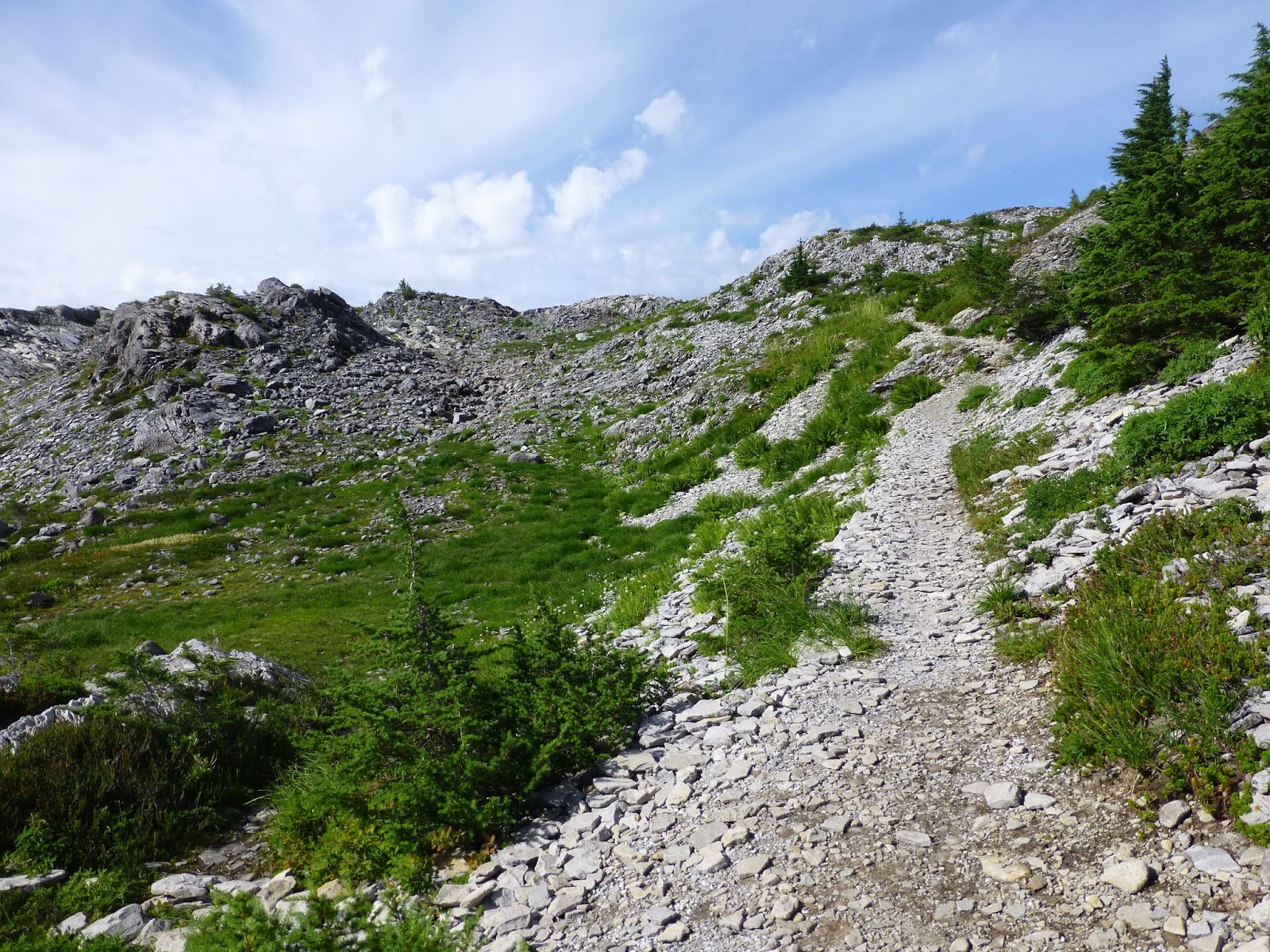
So, last month on my birthday, I went up to Mt. Baker to do a little hiking.  My plan was to do the 6.5 mile Chain Lakes loop trail, but because of snow covering the route, I nixed that.  I gave it some time and decided to try again on Labor Day.  Leaving just after 7:00 am, I made the hour and a half drive up to the Heather Meadows visitor center parking lot.  Getting there early, I hoped to beat the holiday crowds.  After eating my packed brunch, I started off on the trail.  I had done a little research and opted to tackle the steepest part of the loop first.  I walked the .80 mile section of the Wild Goose trail, ascending 800 feet to the Artist Point parking lot.  With trekking pole in my left hand and camera in my right, I took in the beautiful view and snapped a shot of the return trail.  In the center of this photo, to the right of the flat topped Table Mountain, is the saddle where the Chain Lakes trail crests the ridge. 


The Chain Lakes loop is listed as a moderate trail, and I thought I could handle it okay.  It was slow going on the Wild Goose leg due to the steep incline, made even more challenging my the loose rock covering the trail. 


As I trudged up the trail, I was suddenly startled by a loud flurry of wings as two large birds flew out of the vegetation past me.  As one who is always on the lookout for opportunities to take photos of wildlife, I thought I had missed a chance.  I scanned the area they originated from and spotted one remaining bird warily eying me.  The bird looked like a grouse, most likely a female blue grouse.  I kept as still as possible as I took a few pictures of the bird as it slowly walked around me. 


When I reached the Artist Point parking lot, I spoke to a guy providing information to visitors to verify that the Chain Lakes trail was clear of snow.  Then, I headed out on the trail, which traveled along the southern flank of Table Mountain, with Mt. Baker towering above.  It was pretty easy going as the trail was mostly flat and only a few sections of loose rock.


As I walked along, I noticed butterflies flitting among the rocks and feeding on the wildflowers growing along the trail.  They moved pretty quickly, but I managed to get some pics.  Here are a couple of a Mormon Fritillary and a Milbert's Tortoiseshell. 


The nice thing about hiking around Mt. Baker, you have easy access to free snacks.  There are wild blueberry bushes everywhere, and even with the large number of visitors, there is more than enough for everyone!  At one point along the trail, I snacked on berries as I looked back at Mt. Shuksan in the distance.


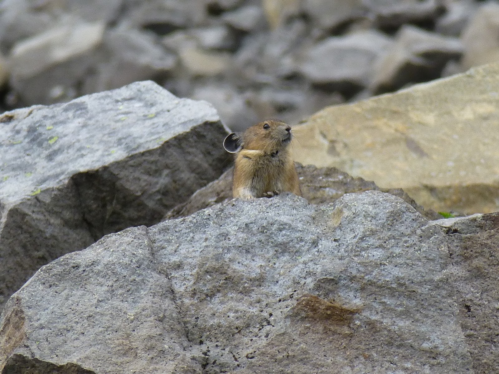
Continuing on, the trail circled around the eastern end of Table Mountain, then headed down over a large area of loose talus.  It was here that I heard the first whistling vocalizations of pika.  Pika are small rodent-like mammals, closely related to rabbits.  They live in burrows among the rocks and spend much of the summer collecting vegetation to create hay piles which they feed upon during the winter.  I had never seen pika, and was eager to catch a glimpse and hopefully get some pics.  After listening to the whistles, I finally spotted one and got my money shot. 


The trail kept going down as I reached a series of small lakes.  It was much damper in this area, which encouraged growth of native plants and wildflowers.  Oh, and more blueberries.


I took a breather as I looked down upon Hayes Lake.  I had hiked about four miles and I found myself running out of steam.  I had underestimated how tough the trail conditions were.  Dirt trails I could handle, but the addition of the talus made things much more challenging.  As I started walking again, the trail started climbing via a series of switchbacks.  It was tiring, but my frequent picture taking gave me a ready excuse to rest. 


When I finally crested the top of the trail, I looked down at the last couple of miles ahead of me.  The end of my journey was elusively close, but I still had a lot of rocks and switchbacks to negotiate on the downward leg.  As I kept going, I had my eyes and ears peeled for any additional chances to see more pika.  My vigilance was rewarded when I got another photo opportunity along the way.


After one last big rock pile and many, many more switchbacks, the trail leveled off and I slowly made my way along the half mile homestretch.  As I returned to the parking lot, I was so tired, but I still felt a sense of accomplishment.  I hiked the entire Chain Lakes loop, which was more than most people were doing on that day.  Will I ever take the challenge again?  I'll never say never, but there are a lot of other trails to check out.  And, I'm glad to say I got many nice photos to capture my experience.  


Saturday, September 7, 2013

Flying high with The Eagles

About three months ago, I found out The Eagles were coming to Seattle.  As a child of the seventies, this band holds a special place in my musical heart.  From their classic hit song Take It Easy...written by one of the founding members of The Eagles, Glenn Frey and another favorite artist of mine, Jackson Browne...to Heartache Tonight, they provided me with a decade of fantastic songs.  I had never gone to an Eagles show, why, I'm not exactly sure.  I guess I COULD blame it on the concert doldrums...that period of time shortly after I graduated college where the opportunity to listen to live music was almost non-existent.  Of course, things all changed when I discovered Five For Fighting, and you know how it is now.

Anyway, I decided I wasn't about to pass up the opportunity to finally see The Eagles.  Now, I wouldn't have minded seeing them alone, but I knew it would be more fun to go with someone.  I asked around and found a friend who also loved their music, then went ahead and bought tickets for the show.  Fast forward to this last Wednesday.  The concert in Seattle was the current stop of the History Of The Eagles tour.  The sell out crowd at Key Arena consisted primarily of older folks...people who like myself have followed the band from the beginning.


With the tour theme of the History Of The Eagles, the band performed most of their well known songs in chronological order.  Glenn Frey was joined by fellow founding members Don Henley and Bernie Leadon, as well as Joe Walsh and Timothy B. Schmit.  After hearing just a few songs, it was evident these guys had lost little over the years.  Their music and awesome harmonies filled the arena with nostalgic bliss.


They performed for about an hour, and after a 15-minute break to take a breather and move things around on the stage, they continued on for another hour and a half.  The appreciative audience was pretty laid back, which was totally understandable...the music itself is mellow and relaxing.  There were two encores, and they saved the best for last...their biggest hits Take It Easy and Hotel California.  


I can honestly say it was one of the best concerts I've ever been to, and probably the first time I had gone to a live show put on by artists I've grown up with.  I can't wait for what October will bring...more music on the horizon.