Monday, September 30, 2013

Land of the Navajo

Had a pretty busy day...I visited FOUR states!  Actually, it wasn't all that busy and it wasn't that hard to accomplish.  After leaving Cortez, CO this morning, I drove about 45 minutes west to the Four Corners Monument. This monument is administered by the Navajo Nation and its location is the only place in the country where four states meet at one central point. 


My activities for the day continued within the Navajo Nation with my visit to the Navajo National Monument.  This is a fairly small park, but it was worth taking a short walk along the paved Sandal Trail to see their Betatakin cliff dwelling.  Although only seen from an overlook, that and the surrounding views were impressive. 


I also hiked the dirt Canyon View Trail to get a better look at...the canyon.  Betatakin Canyon to be exact.  And, I DID view the canyon, too!  Oh, and I took some photos.


As I was leaving the park, I was a bit disappointed that I didn't get my customary animal pic.  It was like someone was listening to me as animals literally threw themselves in front of my Blazer.  Well, maybe I'm being a bit melodramatic.  I had to stop for the sheep crossing.  Apparently, it's not uncommon to see sheep in Navajo Country.  AND, I got my animal pic!  Sweet!


After stopping for gas in Page, AZ, just a short distance down the highway I came upon Glen Canyon Dam.  Located on the Colorado River, the dam creates Lake Powell, a popular recreation destination.


Tomorrow, I'll be traveling to Las Vegas for a little night of entertainment.  No, scratch that.  For a BIG night of entertainment!  I'm seeing Elton John for the first time!  Needless to say, I'm SO excited!  After days of driving and hiking, I really need something like this.  I wonder if they'll let me take some pics...

Sunday, September 29, 2013

Mesa Verde: Land of the Pueblo People

I've always wanted to visit Mesa Verde National Park.  In fact, it had been on my wish list every time I go on one of my road trips.  But, it just never seemed to work out.  Not along my route and too far away come to mind as the reasons the park was never included on my itineraries.  But, this trip was different.  When I was planning my vacation, I made it a point to include Mesa Verde first, then work everything else around it.  So, today was the culmination of a couple months of planning. 

I arrived at the park nice and early, about 8:30 am.  At the visitor's center, I bought a ticket for a ranger-led tour of their largest and most famous cliff dwelling, Cliff Palace.  Mesa Verde is famous for their cliff dwellings, the remnants of ancient peoples who lived in the area from about 550-1200 AD. 


The photo above gives a closer view of how the Pueblo People...formerly known as the Anasazi...constructed the walls of their dwellings.  Researchers have determined the age of these dwellings by analyzing the rings of logs used in their construction. 


The circular structures you see in the photos are kivas.  These dwellings originally had roofs and were generally thought to be used as meeting places rather than homes.  After my tour of Cliff Palace, I drove to the Spruce Tree House for a self-guiding tour of another cliff dwelling.  Here, I was able to actually climb down inside a kiva...pretty cool!  Spruce Tree House is the best preserved cliff dwelling in the park. 


The rest of my day was spent exploring the park and viewing other sites previously inhabited by the Pueblo People.  Traveling south along the Mesa Top Loop road, I first stopped at the Navajo Canyon overlook to take in the view.

 
Before moving to the cliffs, the ancient people lived above ground on the mesa.  This fact is most evident in the remnants of pit houses and stone masonry buildings found in the park.  Oh, and there were more cliff dwellings to be seen from the mesa top. 


And, in case you were wondering...yes, I have a couple of animal pics.  Lizards again!  Not sure what species these guys are, but they were pretty generous staying still long enough for me to get my shots!  Hey, I don't have lizards where I live at home...can you blame me for my enthusiasm?


And, so ended my awesome day at Mesa Verde National Park.  Was it what I expected?  Yes and so much more!  There aren't many places like this in the world...especially one close enough for me to visit.  As of now, I've reached the farthest point away from home in my road trip journey.  Tomorrow, I start the slow trip back to the Northwest.  I may still have a short hike or two along the way, but this week the emphasis goes from entertaining myself to someone entertaining me.  Stay tuned...
 

Saturday, September 28, 2013

Island in the Sky

Lip balm!  I need lip balm!  Chapped lips is something I usually don't have to deal with, living in the moisture rich northern Puget Sound area of Washington. But, here in the Utah desert, my lips were in need of relief.  And, I didn't have any lip balm with me!  Before leaving my pit stop in Green River, I stopped to grab a breakfast sandwich from Subway.  Conveniently, the restaurant was sharing a building with a mini-mart.  So, I got my sandwich AND my lip balm!

My sole destination of the day was Canyonlands National Park, specifically the Island in the Sky district.  This section of the park is generally a large, spread out mesa, surrounded by spectacular basins and canyons.  The weather was perfect, sunny with a blue, cloudless sky and temperatures hovering in the high 50s.  I much prefer doing my outdoor activities in cool weather, wearing just a light jacket...or none at all.  My first stop of the day was Mesa Arch.  Not the biggest arch by far, but you can't beat the awesome backdrop!  In addition, from the overlook, I looked down on Buck Canyon. 


Next, I drove to the end of the Grand View Point road to hike the one mile trail to the Grand View Point overlook.  As I walked along the dirt and sandstone trail , I soaked in the views and of course, took lots of photos.  At one point, I saw a blur of movement out of the corner of my eye.  Chipmunk...a Hopi chipmunk to be exact!  The little critter stopped and started eating the flower pods from a plant.  So cute!  Then, I saw a good-sized bird fly to the edge of a cliff and start vocalizing.  I managed to snap a pic of this female northern flicker before it flew away. 


When I reached the end of the trail, I decided to try out my camera's panorama mode.  Since buying the camera last year, I hadn't used this feature.  I took shots of both sides of the overlook...Monument Basin and Junction Butte.  I think the photos came out pretty good!


I was ready for lunch.  I parked at the Buck Canyon overlook and looked for an appropriate rock to sit and enjoy my meal.  In my search for a flat stone seat, I almost stepped on a lizard which scooted away from me.  Strangely, it didn't go very far, choosing instead to sit and eyeball me.  This behavior made it very easy for me to get some nice pics.  After my meal, I took some photos of the scenery from the overlook.  This shot includes both Gooseberry Canyon and Monument Basin. 


My second hike of the day was half the distance, but had a little more elevation.   The trail to Upheaval Dome proved to be just as popular as the Grand View Point trail.  At the top, the viewpoint looked down at...a crater, not a dome.  Scientists speculate it was caused by a meteor strike, but it sure stands out from all the geological features in the park.  


Before leaving the park, I took in one last viewpoint...the Shafer Canyon overlook.  It provided one last spectacular vista and was a fitting ending to a wonderful day at Canyonlands National Park.  Someday on a future road trip, I need to check out other areas of the park that I didn't have time to see.


Friday, September 27, 2013

There be goblins in the valley

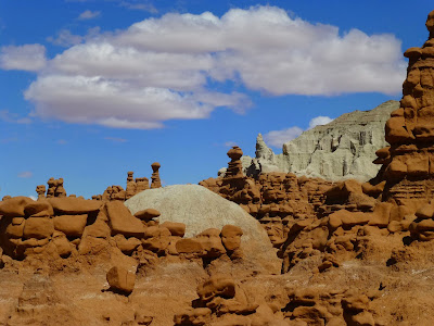
When I left Brigham City, UT this morning, it was a bit chilly, but NOT raining!  A few hours later, I was driving over the mountains east of Spanish Fork...SNOW covered mountains!  It wasn't snowing, but temperatures were near freezing!  My destination of the day would be Goblin Valley State Park, located in central Utah.  While I was planning my road trip, I stumbled across this place and I knew immediately I had to add it too my list of must-see places.  You'll see what I mean.


That's Wild Horse Butte in the background, and as you can see, it was nice and sunny today!  Perfect for taking pictures, and I took a LOT of those!  Goblin Valley is famous for its sandstone hoodoos or goblins made of Entrada sandstone.  There are literally THOUSANDS of these goblins, shaped by wind and water and totally unique from other rock formations in Utah.  It was fun walking among the goblins, and there wasn't a lack of picture perfect views.


Doesn't the photo above remind you of a futuristic city in a sci-fi movie?  After leisurely walking among the goblins, I decided to take a little hike.  From the parking lot, I took the 1.5 mile Carmel Canyon Trail.  The trail was mostly dirt, with some sandstone slick rock in places, and the scenery was just as awesome as Goblin Valley.


This particular trail was listed as moderately strenuous, and for the most part, I thought it was pretty easy.  But, I was surprised when toward the end of the hike I was presented with quite a challenge.  The trail was following a sandy dry wash when suddenly it narrowed between sandstone walls and ended with a rather high shelf of smooth rock.  Now, how was I supposed to get up that?  I pondered my situation...made harder by the fact that I'm short...and opted to shimmy up using the sides of the rock walls.  It's a good thing I'm in pretty good shape.  I was patting myself on the back for that feat when I came across ANOTHER shelf, this one a bit harder.  I managed to find enough of a foothold in the wall to work my way up that one, too.  

Of course, my photo album wouldn't be complete without the flora and fauna.  AND, I got pics of a couple of different lizards.  They were pretty small...only a few inches long...and could have been babies.  I also got a nice shot of a desert wildflower.


Tomorrow...you got it!  More rocks!  I never get tired of seeing different kind of rocks and natural terrain.  That's what make Utah so great.  There are SO MANY national and state parks to choose from, and it will be my first visit to this one. 

Thursday, September 26, 2013

Every day's a new day

When I got up this morning, the view from my hotel room showed a few light rain drops falling.  But, I was feeling optimistic.  I didn't want a repeat of yesterday's terrible weather, and I was pretty sure today would be  better.  It was only a two hour drive from Twin Falls, ID to my sightseeing destination of the day... City of Rocks National Reserve.  Never heard of it?  Well, neither had I until the park popped up on a search of places to see on my way to Utah.  I stopped at the visitor's center in Almo, ID, then headed up a well-maintained dirt road to the park.  Even though it was a bit cloudy, I could deal with that...at least there was no rain and the sun peeked through now and then! 


The park's name is a pretty good description of what it's all about...a LOT of rocks!  A CITY of rocks!  Wind and weather have shaped the rock formations, and like other parks, there are some highlights.  This is Elephant Rock...popular with the rock climbers.  In fact, if you look real closely, you can see a guy getting set up to climb it! 


 The park also has its resident arch...the rather small Window Arch.  And, yes, I was standing right in front of it.  Right after I took a few pictures of the arch, a bird flew by me and landing on a tree.  Always on the lookout to snap animal pics, I manage to get a shot before it flew away.  I'm pretty sure this is a Townsend's Solitaire.


After lunch, I really wanted to put in a hike.  I chose to do about a three mile loop, starting first on the Creekside Towers Trail, connecting with the Stairways Trail and returning on the South Fork Circle Creek Trail.  There was no one else around, and it was so peaceful walking the moderately easy dirt and slick rock trail.  I took a LOT of photos of rock scenery...better too many than too few! 


There are many rocks within the park bearing the signatures of emigrants that in the past two centuries used to live in the area or were just passing through on the California Trail.  Many of them used axle grease to mark their presence on the stone.  Before I left the park, I stopped at the Emigrant Register to look at some of those signatures.


As I was returning to my Blazer, a bird landed on a power line above me.  It was a bluebird...a female mountain bluebird to be exact!  How pretty!  I had never seen one of these birds before.  I slowly brought my camera up, trying not to scare it before I could take a few pics.  It was almost like the bird was saying goodbye, thanks for visiting.  


It was a fitting end to a great day.  As I left the park, dark clouds moved in and later miles away, I could see it was raining above the rocks.  Thank you, Mother Nature for holding off on the rain until my day was done.